Our changing climate
How is our climate changes affecting Tasmania

To understand how the climate is changing in the north-east region, the north-east councils worked with the University of Tasmania’s Climate Futures Tasmania program. The project looked at likely climate changes at both local council and regional levels.
This information gives councils a clear understanding of local climate risks and helps them make informed decisions to manage those risks.

-
Tasmania’s Northern Region has a temperate climate with moderate temperatures. Near the coast, the average daily maximum is around 21 °C in summer and 13 °C in winter. Inland areas experience greater temperature variations, including very cold nights in winter. Since the 1950s, long-term average temperatures have risen by up to 0.15 °C per decade.

-
Average annual rainfall varies across the north-east region. The north coast receives 800–1000 mm per year, some parts of the east coast get more than 1000 mm, and inland areas such as the midlands and Fingal Valley usually receive less than 600 mm. Much of the rainfall comes from east coast low-pressure systems, which can produce the highest rainfall extremes in Tasmania. For example, Cullenswood recorded 352 mm in a single day in 1974, one of the state’s top three daily rainfalls.
Since the mid-1970s, average annual rainfall has declined across the region, with the biggest drop occurring in autumn.

-
The table below shows the sea level planning allowances for the north-east coastal councils, as identified by the Tasmanian Government.

-
Bushfire risk is increasing across the region as the climate warms, fire seasons become longer, and there are more days with the highest fire danger.

-
The climate changes most likely to affect councils’ infrastructure, roads, local communities, and the environment are an increase in the intensity of extreme events. Specific impacts include:
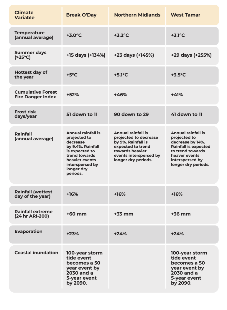
Very hot days may become up to 5 °C hotter.
Longer and more intense heat waves are likely to increase the frequency and severity of bushfires.
Short, intense rainfall events are projected to become more severe.
Rainfall patterns are expected to shift to heavier events separated by longer dry periods. High daily runoff events may increase, raising the risk of erosion and flooding. Rainfall in a 200-year average recurrence interval (ARI) event is expected to increase by about 16%.
Coastal inundation will rise. The current 100-year storm tide is around 1.9–2.0 m above average sea level. With a projected sea level rise of 0.82 m, this 100-year event could occur every 50 years by 2030 and every 5 years by 2090.
COUNCIL CLIMATE PROFILES by 2100
The eight northeast councils worked with the University of Tasmania’s Climate Futures Program, in 2022, to develop council-wide climate profiles for each of the 8 northeastern municipalities. The profiles can be used by councils to help make operational and strategic decisions about climate impacts, as well as the community to inform them of climate risks so they can decide how they should best respond.
-
Climate change science | ReCFIT
What are the projected climate change impacts for Tasmania? | ReCFIT
Understanding Climate Change - City of Launceston
Climate change in Australia – CSIRO BOM Australia Climate Service
Climate change in Australia Southern Slopes (Tasmania East)